Monday, August 22, 2016


Tilt Cove

The next community is Tilt Cove, which is now Canada’s smallest town.  The town’s name may have come from the term for a fishing shack (tilt) that had been built on the shore of the cove and which would have been the only structure visible to ships passing the area (More Than Just a Name, Byron A. Brooks, www.travellingnl.com).

Although tiny now, it was once a vibrant and booming mining community, the second largest in Newfoundland, with over 2000 people, four churches, each with its own school, a couple of banks, and a large copper mine supporting it all.  The mine operated from 1864 for about 50 years, opening again in 1957, and finally closing 10 years later (http://www.cbc.ca/news/canada/newfoundland-labrador/tilt-cove-newfoundland-smallest-town-1.3260204). As of this August, there are now 5 residents in the summer, and we were told there would be just 4 this winter.  The town became famous for its size in 2015 when Marvel reached out to request help in getting a small poster for the upcoming Ant Man movie placed in Tilt Cove, stating “It’s the perfect match."  The ant-sized billboard is still there in the town.

Ant Man sign

The history of the town is captured by the residents in The Way We Were museum, and resident Margaret Collins took us through the pictures, artifacts and stories that have been saved there.  It was interesting to compare the pictures of how it used to look to what structures still remained.  The residents are always happy to take tourists through the museum and explain how life was in a busy mining town, and it’s well worth a stop.

Pictures, stories and artifacts in the museumItems once treasured
A reminder of how life wasPreserved history
An aerial view of the town when the mine operatedSome of the many mining buildings
Lots more houses thenThere were many regattas on the pond
A view of the town looking towards the oceanSimilar view today
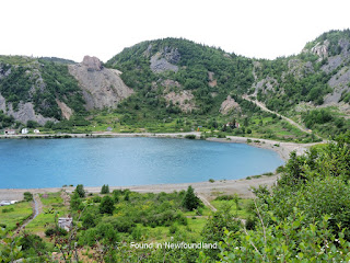
The community is built in a bowl between the hills accessed from a road high above the town, and the remaining houses are clustered around a central pond at the bottom – older, abandoned houses on one side and more modern and inhabited houses on the other.


Newer houses at top of pond, older houses at bottomThe town is surrounded by hills and slag
Some of the older houses, still standingIf this house could tell stories...

Very little of the mine remains, except the loose rocks covering what were once entrances, some old support structures, and memories.  Much of the mine was actually above the town, behind what is known as Castle Rock, a large knob in the cliff.  You can still see the road that used to lead to the mining area.

Castle RockRoad to mine area at right
Old mine shaft, now filled inOld mining structure, all that remains
You can drive down a short road to visit the beach, where there is a picnic table under an old mine support and overlooking the sparkling bay, where there were a couple of small boats moored.  Scattered on the beach, you can still see a glint of copper in some of the rocks.


The rivers near the mine shafts still show much rustYet this hardy flower holds on
Beautiful beach on Notre Dame BayThere's a small cave behind this boat
Glints of copper and minerals in the rocksJust a hint of what first explorers found

There’s not a lot to see here now, and yet there’s something very special about this town that touches the heart.

For more information on the story of Tilt Cove, you may be interested in an episode of Land and Sea, featuring the residents talking about what life was like and how the mine was discovered.  The mine is also featured in a book on mining in Newfoundland, Once Upon a Mine, which you can read online.

Next post:  We're going to jump ahead - come back soon to see where

Saturday, August 20, 2016

Shoe Cove

Our first stop of the day was Shoe Cove, which is just a few minutes from La Scie.  We were fortunate to have a fairly good paved road all the way down to the community.  (As you'll read later, that isn't always the case in this area.  There are some long dirt roads to some of the communities.)  Shoe Cove is a charming small village built around a large pond in the middle of the town. 

Shoe Cove signEntering Shoe Cove
Houses around pondLarge pond at centre of community

Near the road leading to the ocean you’ll find an old community bread oven.  Next to the oven is a plaque which tells an interesting tale about "Jack the Lantern," a mysterious guiding light that appeared in the harbour on a number of occasions, and another special lantern that burned just long enough to bring a casket home from another community on a stormy night only to extinguish itself just as they arrived at the church.


At the end of the town is a small wharf with a large shed.  Perched on the cliffs next to the boat launch are some old fishing sheds, which clearly haven’t been used in many years, but still resolutely stand on narrow stilts, nestled into the rock face. 

Boats on wharfThis old fishing shed could tell some tales
Fishing, then and nowLooking back from the wharf at the other old shed
Ready for the catchThere's a lot of history here
Another visitor we ran into mentioned picking up a lunch at a local restaurant and bringing it down to this wharf to eat by the water, and we thought that was a lovely idea.  It's definitely a nice place to spend some time and reflect on the history evident here and the quiet beauty of a modern outport life.

Next post:  Tilt Cove

Wednesday, August 17, 2016

La Scie


La Scie is a small town by most standards, but the largest on the eastern end of the Baie Verte peninsula.  It has an arena, a ball field, a couple of gas stations and several small stores, but no big shopping centres.  There are three places to eat, including the Outport Museum and Tea Room, which unfortunately we didn’t get to visit (and the two reviewed in this blog).  At the end of town is an RV park for camping, near a beach.  The next nearest large centre is Baie Verte, about 45 minutes away.  The harbour is dominated by a fish plant, but with the cod moratorium, the plant was closed.  Although fishing is still a big industry in the town, everything is now shipped out for processing.

Entering La ScieScenes from La Scie
Scenes from La ScieScenes from La Scie
Scenes from La Scie
(Get similar picture on a mug and a magnet)
Scenes from La Scie
La Scie also boasts some scenic trails.  We were fortunate to have the entrance to two right behind our B&B, next to the arena.  The first we did was the Overfalls Trail, which is marked with a wood border and covered in loose rock, so it’s easy to follow.  It winds through the woods with a gradual slope, finally crossing a small river where there was just a trickle of a waterfall, but which is probably beautiful when the river is running strong.  The trail ends at the cemetery.  We decided to walk back via the road, and the whole trip took just over an hour at a leisurely pace.

Not much water in the "falls"

The second trail is Boone’s Hill Trail, also accessible from the arena.  We did this trail at the end of a long day, so we went just far enough to watch the sun setting over the water.  The trail starts out fairly easily, but becomes a steep slope covered in loose rocks after crossing a dirt access road.  With the slope and loose pebble covering, I found this section very slippery and difficult.  However, once you get to the top of that section, there’s a bench where you can sit and look back over the town, and the trail flattens for a while and leads out to the edge of the cliffs over the harbour.  From there, you can continue towards another climb to a lookout platform a little higher on the hill, or down towards the RV park and Island Cove Beach.

Looking back towards the townThe trail goes down to a beach and up to a lookout


Beautiful sunset
(Get similar picture on a canvas)

Supper on our second night was at Critch’s Restaurant & SnackBar.  With a casual name, we expected a small place with a couple of diner tables along a large counter, but attached to the area with the counter was another room laid out with several small cloth-covered tables and a surprisingly varied menu.  My husband decided that the chicken tasted exactly like KFC.  I had a wrap that was stuffed full of meat, lettuce, tomatoes, and cheese.  The staff were friendly, not only remembering us from stopping by earlier to get some sandwiches for the road, but sitting down with us and chatting about things to see and do in the area.  The snack bar portion also has a selection of ice creams, slushies, and desserts as well as some quick take-out options.

I definitely recommend at least two full days to really get to visit each community along the peninsula, and although there are a lot of similarities, each is unique with its own beauty.  What follows will be a series of posts about each of the communities we visited and some pictures of what we found there.  One tip:  Most of these communities are very small and do not have or need a lot of public services, so don’t expect to find places to eat or access to washrooms.  You will need to plan accordingly.

Next post:  Shoe Cove